


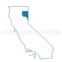
Voting District 10010, Lassen County, California
About
Outline

Summary
| Unique Area Identifier | 532518 |
| Name | Voting District 10010 |
| County | Lassen County |
| State | California |
| Area (square miles) | 508.29 |
| Land Area (square miles) | 495.28 |
| Water Area (square miles) | 13.02 |
| % of Land Area | 97.44 |
| % of Water Area | 2.56 |
| Latitude of the Internal Point | 40.51876940 |
| Longtitude of the Internal Point | -121.10378180 |
Maps


Graphs
Select a template below for downloading or customizing gragh for Voting District 10010, Lassen County, California


Neighbors
Neighoring Voting District (by Name) Neighboring Voting District on the Map
- Voting District 10025, Lassen County, CA
- Voting District 20015, Plumas County, CA
- Voting District 30025, Plumas County, CA
- Voting District 30300, Shasta County, CA
- Voting District 40080, Lassen County, CA
- Voting District 40085, Lassen County, CA
- Voting District 50505, Shasta County, CA
- Voting District 50506, Shasta County, CA
- Voting District 50507, Shasta County, CA
- Voting District 50515, Shasta County, CA
Top 10 Neighboring County Subdivision (by Population) Neighboring County Subdivision on the Map
- Central Shasta CCD, Shasta County, CA (11,527)
- East Shasta CCD, Shasta County, CA (7,475)
- Chester CCD, Plumas County, CA (3,957)
- Greenville CCD, Plumas County, CA (2,601)
- Westwood CCD, Lassen County, CA (2,534)
- Big Valley CCD, Lassen County, CA (1,483)
Top 10 Neighboring Place (by Population) Neighboring Place on the Map
Top 10 Neighboring Elementary School District (by Population) Neighboring Elementary School District on the Map
- Susanville Elementary School District, CA (11,632)
- Black Butte Union Elementary School District, CA (4,366)
- Whitmore Union Elementary School District, CA (726)
- Ravendale-Termo Elementary School District, CA (166)
Top 10 Neighboring Secondary School District (by Population) Neighboring Secondary School District on the Map
Top 10 Neighboring Unified School District (by Population) Neighboring Unified School District on the Map
- Plumas Unified School District, CA (19,367)
- Fall River Joint Unified School District, CA (8,042)
- Westwood Unified School District, CA (1,821)
- School District Not Defined, CA (710)
Top 10 Neighboring State Legislative District Lower Chamber (by Population) Neighboring State Legislative District Lower Chamber on the Map
Top 10 Neighboring State Legislative District Upper Chamber (by Population) Neighboring State Legislative District Upper Chamber on the Map
Top 10 Neighboring 111th Congressional District (by Population) Neighboring 111th Congressional District on the Map
Top 10 Neighboring Census Tract (by Population) Neighboring Census Tract on the Map
- Census Tract 126.03, Shasta County, CA (4,134)
- Census Tract 127.02, Shasta County, CA (3,083)
- Census Tract 4, Plumas County, CA (2,785)
- Census Tract 402, Lassen County, CA (2,534)
- Census Tract 5.01, Plumas County, CA (2,146)
- Census Tract 401, Lassen County, CA (1,822)
- Census Tract 5.02, Plumas County, CA (1,811)
Top 10 Neighboring 5-Digit ZIP Code Tabulation Area (by Population) Neighboring 5-Digit ZIP Code Tabulation Area on the Map
- 96130, CA (23,150)
- 96137, CA (3,297)
- 96020, CA (2,416)
- 95947, CA (1,899)
- 96040, CA (341)
- 96071, CA (125)